12 December 2008

Crater Lake, Indian Peaks Wilderness


4th of July weekend, 2008. A small group of us had wanted to get into the heart of the Indian Peaks Wilderness to see Lone Eagle Peak for quite some time, so we planned a trip over the long weekend. The small group exploded quickly into more than a dozen friends (and 3 dogs) that were up for the long, ~8 mile each way, hikes in and out and 3 days of backcountry camping without fires! The picture above is of one of the more spectacular waterfalls we passed on the way in.


Missy and Bailey about 2.5 miles away from the campsite. Each of us was carrying our own gear, food, and water for the 3+ days we were in the wilderness....plus every other person or so also had a tent.... and Jack also had a wiffle ball set (according to him, it wasn't 4th of July without a baseball game or something like it). Most of the packs weighed between 20 and 30 lbs.... so needless to say our backs and shoulders and legs were happy to finally make it to the campsite.


One of our first views at Crater Lake, where we camped.


Our first view of Lone Eagle Peak, our initial inspiration for planning the trip.


Me crossing one of the many makeshift creek crossings.


Lone Eagle through the trees...


Crater Lake is surrounded on all sides by 12,000+ ft ridges... makes for quite a spectacular setting. It was definitely more beautiful than any of us had imagined.


Nearing sunset on the first day.


Smaller than Crater Lake, Mirror Lake is aptly named. It was pictures like this one, with the perfect pinnacle of Lone Eagle viewed head on like this, that inspired us to go up there. We originally wanted to climb the peak (a class 4 scramble is the easiest route), but once there, we opted to just relax (mostly) for our full day and enjoy where we were.


Another of the views from Mirror Lake and by far my favorite picture from the trip.


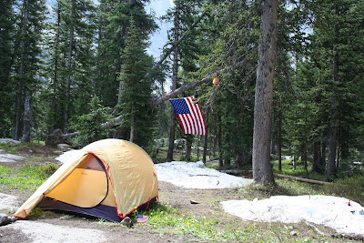
My tent: home for Bailey, Missy, and I for the weekend. It was July, but at almost 10,400 ft altitude, the air was only warm in the Sun, and as you can tell from the pictures, there was a fair amount of snow left up there. Our worst bit of weather came in the form of a short, but solid bout of rain and hail. Overall, we did have great weather though.


Oh, Jack also hauled up American Flags...AND an apple pie.


Along the creek connecting Crater and Mirror Lakes...


While most of the (harder-core) crew tried to tackle the West ridge line, Missy and Bailey and I took a more leisurely hike partway around Crater Lake. This is looking back East from the West shore.


Lone Eagle's true form is given away from the West side of the lake. What appears to be the "perfect mountain" from the North is really just the end of another ridge. Lone Eagle's summit isn't even the highest point along the line!


Missy and Bailey waiting on one of the bigger rocks below, I climbed up a bit for a better vantage. From up here, I enjoyed full views of Crater Lake like this.


Another profile of Lone Eagle.


I went partway up this waterfall. Turns out the rest of the crew took this the entire way to the top before doing a bit of glissading down the larger snowfields above.


The ever-present, and ever-beautiful Colorado columbine. We actually saw a few red columbines on the way down. According to Jack, our local expert, the red ones are extremely rare... he had never seen one before this trip! The red ones were much smaller and not fully in bloom, so they weren't as photogenic as the one above.

07 September 2008

Northern Ireland


Derry city, Northern Ireland. I was personally expecting some kind of border crossing after our day of driving through Galway, Sligo, and Donegal. Yet, when we got into N. Ireland, the only thing that gave it away were the license plates and traffic signs. It took me a couple minutes to realize that the speed had switched from kph to mph, which meant the people behind me weren't too thrilled. Anyway, Derry city, also known as Londonderry, has long been an English stronghold in the country (since the 1500's). It is an interesting and lively city with an even more interesting history. Its city center is still surrounded by its medieval city walls. Still fully encircling their original perimeter, these represent some of the best preserved city defenses in Europe. Missy and I walked around on top of half the circumference, but had to get down since they access points are locked up at sunset.

One of the 4 gates along the wall. The wall has plenty of placards discussing the history. Bishop's Gate is seen here with its placard and a few tidbits.


Derry has plenty of murals. Many are republican, but this is a unionist one. Derry was one of the hottest of hotspots during "the troubles." Bloody Sunday occurred here, and for a time, there were sections of the city, called Free Derry, which were essentially run by the IRA and definitely not places where English or Unionist citizens were welcome.Derry City Independent hostel...by far the comfiest, welcoming, and clean hostels I have ever stayed in. I don't even know if you can call this a hostel....it was more like staying at a good friends lovely townhouse. It was decked out in various Asian art, furniture, and Buddha statues and had amazing washrooms.


Our double bed room. I wish we could have stayed here for a while...it was a great hostel and a cool city to explore, but we were nearing the end of our trip and still had plenty to see!


The Antrim Coast....a must see stretch and a must do drive. The Antrim Coast road runs around the northeastern coast past picturesque coastline and many amusing attractions, both natural and man made.


The Giant's Causeway...remarkable to see despite having to share it with way too many tourists.


Walk around while at the causeway, especially if the weather is as nice as we had when we were there.


These polygonal basalt columns are the Giant's Causeway. There are an estimated 37,000 of them ranging in height from a few inches to 10's of feet. Hexagons are the most common shape, but they can have as many as 10 sides. Irish legend has it that Finn McCool (actually Fionn Mac Cumhaill in Irish), a warrior from Ulster, fell for a woman giant from Scotland and built the causeway to cross the sea to get to her (the fault line along which the formation lies does indeed resurface on a Scottish island), and another legend tells of Finn building it to go to Scotland to fight another giant. The legend goes on to say that when Finn got to Scotland, he was surprised by the superior size of his Scottish foe. He fled back to Ireland and was pursued by the other giant, but Finn cunningly had his wife build a giant crib in which he hid cuddled up in blankets. When the Scottish giant showed up to fight, he in turn was frightened by the sheer size of Finn's "baby" and fled back to Scotland...good moral to that one eh?!?


According to geologists, the causeway actually formed by a massive subterranean explosion that shot molten basalt up to the surface where it cooled and basically crystallized into these shapes.


We had a beautiful day while we were driving the coast road. It started out overcast, but the sun cleared the clouds away, leaving perfect blue skies and this amazing ocean of turquoise.


The Carrick-a-rede rope bridge...definitely worth checking out. The island is connected to the mainland by an old rope bridge (which is now reinforced by steel cables), which was originally built by fishermen. It was hilarious to see how frightened some people got when it was their turn to cross, I loved it!


Belfast, the capital of N. Ireland. Belfast is a very large city, and Missy and I only spent a few hours here. Overall, I found the cities of Northern Ireland to be much too big and industrialized compared to their equivalents in the Republic. Both Derry and Belfast seemed like they had lots to offer though, and I hope that if I ever get back to either, I will be able to spend a bit more time enjoying them.


There was a continental food fest going on outside of City Hall, seen here. There was plenty of food from all over Europe here, which was really cool. Missy and I ended up going for a bit of French (a potato and cream with ham dish...and absolutely delicious) and a bit of German (bratwurst). This will end my Irish post. Our last full day, Missy and I drove back from Belfast to Dublin via Dundalk and the Bru na Boinne site, with its prehistoric tomb-mounds and passage graves. Overall, I absolutely loved Ireland, and will do my best to return again sometime in the future.

04 September 2008

Ireland: Counties Sligo and Donegal


This picture is totally out of place, but I wanted to start out with a good one. So on this day, we drove from Galway city to Derry in N. Ireland, but we decided to take a little bit of a roundabout route (see map in previous post) to explore a bit of County Donegal, which is famous for its beauty. At this point though, we were well aware that practically the whole island is famous for its beauty, but we just didn't want to miss out on this, especially since Donegal is the birthplace of my now infamous patchwork cap.


This was actually taken in county Sligo. We pulled off to see a waterfall shortly after the town of Drumcliffe. The body of water is Glencar Lough, which sits beautifully between the tree-lined slopes of the Dartry Mountains. It was a beautiful setting. The waterfall was nice too!


We zipped pretty quickly through County Sligo and up into Donegal. When we got into Donegal town, we were expecting to stop for lunch, but were met by some heavily armed military personnel (and I do mean heavily armed...these guys had fully automatic assault rifles) in the town-square, which seemed lovely. We were quite intimidated and figured there must be something special or dangerous going on and just passed through. It seemed like a nice town though! Anyway, we ended up stopping at this beach slightly west of town to picnic.


Looking west along the Donegal coastline.


After our disappointing day at the Cliffs of Moher and our unfortunate bit of luck with the cliffs in County Kerry, we really wanted to see some of Ireland's famous west-coast cliffs in full sun. Donegal happens to have reputedly the highest cliffs in Europe! It just turns out they were hard to find...we knew where they were, but couldn't find the road (turnoff really) to get to them! Anyway, these cliffs lie on the southernmost peninsula in the county, almost at the very tip. We ended up driving around their backside, which were still scenic, but not what we wanted, through a very country-side setting with a lot, and I mean a lot, of peat extraction by the locals. We drove out to the very tip, to a small community called Malinbeg, and found this little gem. This beach was boxed in on three sides by these cliffs...and though the pictures do little justice, this beach is one of the most beautiful I've seen thanks to this setting.


A steep staircase takes visitors down to the sand. It's a huge strip and walking around you are surrounded on three sides by steep, emerald green cliffsides with the odd crags sticking out here and there, and on the remaining side by the beautifully blue (when fully sunlit) North Atlantic Ocean. There is even a waterfall! Truly amazing setting.


And don't forget the sheep...they were all over the cliff-tops too.


Anyway, we finally found the turnout (on the other side of the cliffs from where we started), and here they are. The Bunglass Cliffs shoot up over 600 meters from the ocean below...3 times the height of the Cliffs of Moher. From up there, the ocean below seems unbelievably distant and leaves one with the false sense that you are too high and too far separated from the waves below for anything to go wrong...weird feeling. Anyway, once again, these pictures don't do justice to the real setting...but they will have to do until you see them yourselves.


A "road" brings you quite a ways up the cliffs. It was pretty sketchy at times since they apparently don't believe in guardrails...or two lanes...or warning signs.


Visitors can hike all the way around to the top of the cliffs....actually they can go all the way around to Malinbeg if they really want (we saw a couple returning from such a hike while we were lounging on the beach). Missy and I hiked part of the way up, but were forced to turn back due to time. At least we finally got to see some cliffs in pleasant weather though!

28 July 2008

Ireland: Connemara, County Galway


On our second day in Galway, we woke up to more rain and decided to get some much needed sleep. By about ten, the rain had stopped, but it was still quite overcast. We started wandering Galway city some more and by about noon, the sky had cleared and the air had warmed. We decided to go for yet another drive. Connemara is the region of lakes, mountains, and rugged coastline west of Galway. Our first stop was the old tower house seen above, Aughnanure Castle. This castle has been remarkably preserved. It still has most of its outer defensive walls, and for a small entrance fee, guests are free to wander the grounds as well as inside the tower itself.


The tower house is built right beside a creek, which definitely acted as part of the castle's defenses.


Inside the Great Hall. Standing in the room, it was so easy to imagine a medieval, wealthy family sitting down to a feast with a massive fire roaring in that equally massive fireplace. The tower also housed some more impressive defenses including a trap door, arrow slits aimed along the main staircase, and a murder hole (a grate above the small area between the two main entrance gates through which boiling oil, arrows and other nasty surprises can be rained down upon intruders).


Connemara countryside...this was right up there with the Iveragh Peninsula for me. The landscapes were so beautiful and welcoming, yet another little corner of Ireland I could easily see myself retiring to.


Mountains and lakes define the countryside here. MLK


I honestly wasn't exaggerating about those roads...MLK


Clifden is a relatively large town at the heart of Connemara. The streets are lined with little shops and pubs, restaurants and cafes, all of which are filled with that Irish charm. Missy and I stopped here for a cup of tea and a snack.


The view out the window at the cafe. The day had become perfectly pleasant, and with the delicious tea and fresh scones (with black current and raspberry jam and fresh butter and cream), it was a surreal little stop that made us linger much longer than we first planned. Clifden is yet another little gem that I will try to stay in the next time I'm traveling around Ireland.


After our break in Clifden, we continued along the road, planning to make a big loop of Connemara before returning to Galway for the evening. These are just some of the scenes we came across during the drive.


We made a stop at Kylemore Abbey. This picturesque old manor house is now a girls boarding school, but the nuns that run it keep a few choice rooms open to tourists (for a fee of 12 Euro). Needless to say, Missy and I were fine enough just lounging about the grounds for a while and taking in the scenery.


Looking down the lake at Kylemore Abbey. While we were there, we saw some plans for the future at the site. They are working on expanding the walled gardens, which are just a short drive from the Abbey, into a massive garden complex.


MLK


Just a little waterfall at the side of the road... MLK


And just the view across the road from the little waterfall.


And some more mountain majesty along R336 on our way back to Galway city.