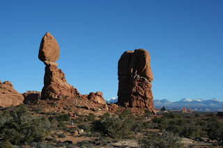
Arches National Park, Utah, USA. Missy and I decided to take a long weekend in November and road trip the ~6 hour drive to Moab, Utah to see the desert, which Missy had never seen before, and check out Arches National Park. It was an absolutely amazing trip, and hopefully these pictures can do it some justice. The picture above is of Navajo Arch in the northern area of the park.

Another out of order picture, but another good one to start this post off. Check out the two guys standing on the top of that central rock...I love this picture for its stereotypical western outdoors-man feel. It also gives a great sense of the sheer magnitude and remoteness of the region. The area around Moab is ideal for anyone who loves the great outdoors, particularly hiking, rock climbing, 4x4ing, and mountain biking.

We took a scenic detour on the way to Moab cutting down along Utah Rd. 128 instead of the faster I-70 to US 191. This road initially cuts off the highway into the desert, taking you directly through the eerie ghost town of Cisco. Driving through there, even in broad daylight, was like something out of a horror film (a la Texas Chainsaw Massacre or The Hills Have Eyes... you know, those ones that are so much more terrifying because crazy inbred cannibals might actually exist, and quite ideally in places like Cisco where the random travelers on a road trip to see Utah's National Parks happen to drive through on this "scenic route"). I was praying we didn't have car troubles. Anyway, after getting through Cisco (which turns out to have an interesting history...check it out on Wikipedia), you start to see these mountains in the distance and the desert starts to get more and more interesting, as can be seen from the next few pictures...


We got to Moab shortly after sunset, and the last part of the drive on UT 128 just kept getting better as the setting sun lit the naturally red and orange rock formations on fire. It was spectacular and surreal.

We spent a full day in Arches National Park, which is enough time to see most of the easily accessible parts of the park (i.e. via paved roads). Arches is a patch of the Earth that has been overly blessed in natural beauty and wonders, including literally thousands of natural arches. It's various rock formations are other worldly and awe inspiring for their grandeur.

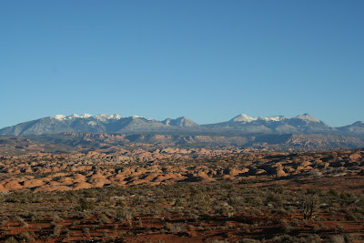
The pictures above and below are panoramic views from a vista near the park entrance...many of the parks major features are visible in the distance. If you look close enough, you can even make out some of the arches!


The Three Gossips rock formation...these ladies are also located close to the main entrance and are absolutely massive. As I so often mention in these blog posts, few of these pictures will do justice for the sheer size of many of the parks features.

The paved roads through the park are wide and well maintained. There are also 4x4 only off-road tracks to reach the more remote regions of the park.

The Fiery Furnace way off in the distance. The amount of different colors and shapes and types of rock and rock formations in such a small area was quite remarkable.

Delicate Arch across the canyon. This Arch is by far the most famous and photographed in the park and for good reason!

As you can see, the Delicate Arch is well named...the stone all around it has been eroded away, yet it's skeletal frame remains. Notice the various people running around it's base...yea...its pretty big!

Close up of the Fiery Furnace. This was one of my favorite places in the park...there were lots of voices coming out of this alien part of the landscape from the various people wandering around through its labyrinthine formations. It is part of the backcountry regions and you need to get a permit to go in to hike or camp.

Skyline Arch...this arch used to be half the size (they have photographic proof) but a massive chunk of rock fell out a while back, literally doubling the size of the arch. Missy and I climbed around on the cracked boulders that fell out. The arch itself sits about 20-30 feet up a vertical rock wall, so it would be quite difficult to stand in this arch.

The whole area, and this picture in particular, reminded me a lot of the Uluru-Kata Tjuta region at the heart of Australia. The colors and extreme sizes and shapes of the rocks brought back a flood of memories. However, Utah doesn't have the nearly blood-red sand and dunes that Australia's Red Center can boast.

Missy and I visited more than a dozen different natural arches during our day in the park, each distinctly different from the one before it. It is an amazing process that carves these arches out...a good reference if you are interested: http://www.nps.gov/arch/naturescience/geologicformations.htm

Landscape Arch: this was my favorite of the arches we saw. It is terrifyingly thin for its enormous span. There was a trail that once led up under the arch, but after a massive section collapsed (right under what is now the thinnest section of the arch, visible on the right side in this picture), the trail was closed to the public....although I must say I was VERY tempted to sneak by the "Closed Trail" sign for a closer look.

View through the Double-O Arch. The picture below shows a little better why it is called the "Double-O Arch"


Sand Dune Arch, we were back here in the mid afternoon and the light was just amazing...the rock was just glowing with this soft pink light.

Turns out those mountains we had been seeing so much of are the La Sal mountains...I hope to get back down to the region sometime to do some hiking in them.


This was called the Parade of Elephants.. though I must say, these elephants were something almost out of a Salvador Dali painting.

The next few pictures are meant to show a sense of scale for these arches....they are absolutely massive structures. There are people in each of the following two pictures as well as the one above.


On our way back home we took UT 128 again...this time we saw it all in morning sunshine and it was spectacular.


